Monday, September 7, 2026

Turkmenistan | Dehistan

After our Visit To Nohur we continued west across the plateau of the Kopet Dag Mountains, finally dropping back down to the desert near the village of Kruzde. 

Village of Kruzde (click on photos for enlargements). 

Continuing on the main road west through the desert fronting the Kopet Dag Mountains we eventually arrived at a tiny town called Garaagas where we pulled into a truck-stop for lunch. If the old American saw that lots of tractor-trailer trucks in front of a diner indicated good food it looked like we were in for a treat. There were nine trucks, all but one with Iranian plates, in the parking lot. The Iranian border was less than five miles away, although the actual border crossing was about forty miles to the west. This may be the first truck stop in Turkmenistan after crossing the border. Actually there were only two drivers in the diner. The rest were apparently sleeping in their trucks. There were two tables with chairs and two low tables on platforms equipped with pillows so you could stretch out and relax while you ate. The cook, a saucy looking woman in her twenties, took your order at a window opening into the kitchen. She must take a lot of guff from the clientele in a place like this, but she appeared fully capable of taking care of herself. She announced that the only thing on the menu was fish, fried. It seemed a bit odd to have fish out here in the middle of the desert, but my driver reminded me that we were only about seventy-five miles from the Caspian Sea. He assured me the fish was fresh and had never been frozen. The fish were probably dropped off here every couple days by dealers plying the highway between the sea and Ashgabat. With the fish we had cabbage slaw, fresh naan (flat bread), and green tea. The fish was white, flaky, not too bony, and delicious. The tea wasn’t fit to slop down hogs (perhaps in part because of the local water) but hey, this was a truck stop. The truckers, I noticed, were drinking Nescafe, probably for its more pronounced caffein buzz (it also disguises the taste of bad water better than tea).  

Just beyond Garaagas we turned off on a gravel road and headed west-northwest through the desert. Soon we stopped. It was time for my driver’s afternoon prayers. Rolling his prayer mat out on the sand, he performed the appropriate prostrations and orisons while I examined the flora of the desert. 

Desert candle / foxtail lily (Eremurus sp., probably E. kopet-daghensis) flowering in the Turkmenistan desert.

My driver reminded me in both appearance and demeanor of a Turkish David Puddy, Elaine’s on-again-off-again boyfriend on the old Seinfeld comedy show. He seemed calm and unflappable but with a sometimes eerie sense of detachment. For someone who had worked extensively with tourists like myself he knew very little English, only a few words in fact. We communicated entirely in Russian. In our time together he never made the slightest attempt to initiate a conversation, which was reason enough to like the guy. That we could drive for hours without exchanging a word was probably even a bigger relief to me than it was to him. In any case he was an excellent driver, and I had no reason to complain about anything. 

After thirty miles we came to the bleak and isolated village of Madau. Sand dunes loomed on all sides and there was not a stick of vegetation around any of the single-story abode houses. The sandy streets were completely deserted. Apparently everyone was indoors. I asked my driver what people here did for a living and he answered laconically with one word: “Gas.” Beyond Madau we veered northward and after about fourteen miles I spied two minarets looming on the horizon. These signaled that we were approaching Dehistan. 

Minarets and ruins of Dehistan looming in the distance


Map depicting the caravan route from Gorgan to Khwarezm via Dehistan
Located on a major caravan route running from Gurgan in what is now Iran to Urgench on the Amu Darya River, Dehistan was the main city of western Turkmenistan from the 10th to 14th centuries. It flourished especially during the reign of the Khwarezmshahs, who ruled Khwarezmia from the 1150s to 1220. 

The walls of Dehistan. The walled city measured 4200 feet long on the southeast side, 2200 long on the northeast side, 4860 feet long on the western side, and 2620 feet long on the southwest side.

The closest tourist facilities to the ruins were probably eighty-seven miles to the north in the town of Balkanabat. We had brought tents and were prepared to camp out on site, but the caretaker of the ruins, who lives with his wife about half a mile away, agreed to let me sleep in a spare room in his house. His wife made us omelets using fresh eggs from the hens pecking around aside the house. They also had the best fermented camel milk I have had outside of Mongolia.

Another view of the ruins from outside the city walls

Ruins of a portal to a mosque and a minaret built by Khwarezmshah Muhammad II (r. 1200–1200). Khwarezmshah Muhammad II was ruling Khwarezm when Chingis Khan Invaded Khwarezmia
 
Ruins of a portal to a mosque and a minaret built by Khwarezmshah Muhammad II

Ruins of a portal to a mosque built by Khwarezmshah Muhammad II

Ruins of a portal to a mosque built by Khwarezmshah Muhammad II

Ruins of a portal to a mosque built by Khwarezmshah Muhammad II

Ruins of a portal to a mosque built by Khwarezmshah Muhammad II

Ruins of a portal to a mosque built by Khwarezmshah Muhammad II

Ruins of a portal to a mosque built by Khwarezmshah Muhammad II

Ruins of a portal to a mosque and a minaret built by Khwarezmshah Muhammad II

The minaret of Khwarezmshah Muhammad II 

Minaret of Khwarezmshah Muhammad II in the foreground and another minaret built by Abu Bini Ziyard in 1004 A.D in the background

Minaret built by Abu Bini Ziyard in 1004 A.D

Minaret built by Abu Bini Ziyard in 1004 A.D

Restored foundations of buildings within the walled city

Restored foundations of buildings within the walled city


Restored foundations of buildings within the walled city

Restored foundations of buildings within the walled city

Original paving stones from the old city

The double wall around the city

The double wall around the city


Ruins of a tower in the city wall

The double wall around the city

The double wall around the city

Denizen of the ruins

Dehistan was apparently invested and sacked by the Mongols when they moved through Khorasan in 1221. The details of this campaign are sparse, but perhaps Chingis Khan’s youngest son Tolui, or a raiding party sent by him, took the city after he had captured Merv. The city recovered, but was abandoned in the 15th century, apparently after the water table dried up, leaving it high and dry in the middle of the desert.

Tuesday, September 1, 2026

USA | Allegheny Mountains | Great Allegheny Passage BIke Trail | Flora | Trout Lily

The Trout Lily (Erythronium americanum) is a true Spring Ephemeral, living its entire above-ground life between snowmelt and the closing of the leaf canopy toward the end of May. It is one of the signature plants of Spring along the GAP and one of the most lovely. GAPers should not expect to find it along the verges of the GAP. It favors moist, rich, humus-heavy soils in part shade to full shade and is commonly found in mature forests of Sugar Maple, American Beech, Oaks, Hickories, and other hardwoods. The genus name Erythronium comes from Greek erythros (“red”). Old friend Carl Linnaeus coined it in 1753 based on the European species Erythronium dens-canis, which has pink-to-purple flowers, even though most American Erythronium species have yellow or white flowers. The species name americanum is simply Latin for “of America.”


Trout Lily has numerous other names, including Adder’s-tongue, Yellow Adder’s-tongue, Serpent’s Tongue, Rattlesnake Violet, Yellow Snakeleaf, and Snakeroot—not to be confused with White Snakeroot (Ageratina altissima), another common plant along the GAP—and Dog-tooth Violet.The snake references come from the sharply pointed shoots that push up in early spring and the protruding reddish anthers, said to resemble a snake’s flicking tongue. The plant was known under these names until the late nineteenth century, when famous naturalist and writer John Burroughs (1837–1921), based in the Catskill Mountains of New York where the plant was plentiful, coined the name Trout Lily, a reference to the mottled purplish-brown leaf pattern resembling the coloring of a brook trout—though the name may equally reflect the plant’s bloom at the start of trout season. Burroughs, who disliked the older name Dog-tooth Violet, in fact preferred Fawn Lily, since leaves “stand up like fawn’s ears,” and the mottling of the leaves recalls a fawn’s spotted coat.


Trout Lily—sticking with the current name—caused quite a stir when reports reached Europe in the 17th century that it was an aphrodisiac. John Parkinson (1567–1650), the last of the great English herbalists and one of the first of the great English botanists, wrote in his mammoth 1629 book Paradisi in Sole Paradisus Terrestris (Park-in-Sun’s Terrestrial Paradise): “Wee have had from Virginia a roote sent unto us, which the naturall people holde not onely to be singular to procure lust, but hold it as a secret, loth to reveale it.” In other words, Parkinson reported that the plant reached England via Virginia, and that Native people there regarded the root as a powerful aphrodisiac—one so effective that they were reluctant to share the knowledge of it. This report set off a craze among 17th-century European gardeners who were eager to get their hands on specimens of the plant. Apparently the craze did not last long.


Trout Lily also attracted the attention of the famous poet Emily Dickinson (1830–1886). She regarded Trout Lily, which she called Adder’s-tongue, as one of the “beautiful children of spring.” It appears in both her youthful correspondence and her poetry, where it becomes a sign that March has arrived and that the sun is beginning to awaken the woods. Her most memorable poetic reference occurs in the poem usually titled by its first line, “We like March”:


We like March—his shoes are Purple.
He is new and high —
Makes he Mud for Dog and Peddler —
Makes he Forests Dry —
Knows the Adder’s Tongue his coming
And begets her spot —
Stands the Sun so close and mighty —
That our Minds are hot —


It is unclear if Dickinson’s interest in Trout Lily was motivated by its alleged aphrodisiac properties. In any case, a pressed Trout Lily was among the 424 specimens of the herbarium she assembled as a schoolgirl, now held in the Emily Dickinson Collection at Harvard’s Houghton Library.


Trout Lily has a long history of use among Indigenous peoples of eastern North America, particularly the Cherokee and Iroquois, and later in American folk herbalism. Its use as an aphrodisiac does not turn up in later reports, but, oddly enough, Iroquois women reportedly used the raw plant (excluding root) as a contraceptive (young girls in particular, according to the ethnobotanical record), while other groups, including the Cherokee, reportedly used it to induce abortions. The corms are edible—crisp, chewy, and pleasantly sweet in early spring—but the plant is strongly emetic in quantity, and digging a corm kills a plant that may have taken seven years to reach flowering size. Nowadays it is seldom foraged or used for medicinal purposes. Trout Lily is now best admired as the beautiful Spring Ephemeral that it is. GAPers seeking aphrodisiacs or contraceptives should look elsewhere.


Trout Lily

Trout Lily

Trout Lily. Note Red-necked False Blister Beetle on the right petal.

Sunday, August 16, 2026

North Macedonia | Tikves Wine District | Demir Kapiya | Popova Kula Winery | Prokupec

It is my fourth day at the Popova Kula Winery, a Thursday, and I am still the only guest here. I checked on the internet and discovered, however, that this coming Saturday night the place is full-up with no rooms available. Luckily I am checking out Saturday morning. Incorrigible misanthrope that I am, I have been enjoying the solitude. Meanwhile I am continuing my investigations of the local vintages. The winery produces eleven different kinds of wine:
—Stanushina
—Vranec
—Prokupec
—Cabernet Sauvignon
—Merlot
—Sauvignon Blanc
—Temjanika,
—Chardonnay
—Zilavka
— Muscat Ottonel
—Muscat Hamburg
Stanushina, Prokupec, Vranec, Temjanika, and Zilavka are made from grapes indigenous to the Balkan Peninsula; these are the only varieties I am interested in. God forbid that I should come to Macedonia just to drink Cabernet Sauvignon or—horrors!— Merlot! 

According to archeological findings, grapes has been grown and wine produced in the area of Demir Kapiya for at least the last 3600 years. The modern history of viniculture in the Demir Kapiya area began in 1927 when King Alexander Karadjordjevic of Yugoslavia (1888–1934) built a winery here to produce wine for the exclusive use of his royal family. Experts assured the king that of all possible locations in his kingdom, which covered a good part of the Balkan Peninsula, including modern-day Serbia, Croatia, Bosnia and Slovenia, this area was the most fertile and best suited for growing grapes and producing wine. He named the property the Winery of The Queen Maria in honor of his wife, Maria Karadjordjevic. The king hired the best vintners available and the winery was soon producing wine of extraordinary quality. Unfortunately King Alexander Karadjordjevic was unable to enjoy the fruits of his vineyards for long. On October 9, 1934, during a state visit to Marseille, France, he was assassinated by Bulgarian revolutionary Vlado Chernozemski.

King Alexander Karadjordjevic of Yugoslavia (click on photos for enlargements)

The subsequent history of the winery is a bit hazy, but apparently it continued producing wine in the decades thereafter, except during the world wars and various local upheavals.  After the Second World the Royal Winery, along with other wineries in what was then Yugoslavia, were nationalized. Over 30,000 families who owned small private vineyards continued, however, to supply grapes to these wine making facilities. It was these people who are credited with  maintaining the high quality of local viniculture during the following decades. After the breakup of socialist Yugoslavia in the 1990s and the emergence of the former Yugoslavian republic of Macedonia as an independent country most if not all wineries were privatized. The royal winery in Demir Kapiya was privatized in 1994 and is now known as the Royal Winery Queen Maria. The current winery has an on-site restaurant and rents out rooms, apartments, and for high-rollers the former villa of Queen Maria Karadjordjevic.

King Alexander and Queen Maria

The Popova Kula Winery is built on lands that once belonged to the Royal Winery. Construction of the winery itself started in October of 2004 and was completed in August of 2005. Construction of the winery restaurant and hotel was not completed until 2009. The name of the winery, “Popova Kula”, means “Priest’s Tower”. Apparently during the time of the Roman Empire an important road ran through the grounds of the current winery. A large tower served as a checkpoint on the road, and this eventually became known at the Priest’s Tower. This original tower was eventually torn down, but the winery has erected a new 55-foot high tower its honor. This tower has become the easily recognizable symbol of the winery. 

Popova Kula Winery

The “Priest’s Tower” of Popova Kula

Curious about this Roman road, I went down to the lobby and questioned the receptionist, a charming woman in her thirties. She in turn questioned one the local workmen who happened to be handy, and this guy said the Roman road in question was the famous Via Egnatia dating to the time of the Roman Empire, which ran from Durrës in what is now Albania east 696 miles to Constantinople, right across the heart of the Balkan Peninsula. This was certainly intriguing. I had already visited numerous cities and towns on the old Via Egnatia, including Thessaloniki, Kavala, and Kastoria in Greece and Orhid in Macedonia but I was under the impression that the old Roman road passed through the Balkans a good bit south of Demir Kapiya. The receptionist called the local wine museum and the woman at the museum suggested I stop by for more information. So I hiked a mile into town and found the museum, a modest two-room establishment in downtown Demir Kapiya. The woman in charge informed me that the Roman road through Demir Kapiya was not the Via Egnatia itself but a side branch of the main highway. Nevertheless, I was thrilled to discover that Demir Kapiya was in fact linked to the hallowed Via Egnatia. I harbor the sneaking suspicion I have traveled this road in a previous lifetime. 

The Via Egnatia in red. The northern extension in green may be the one that passed through Demir Kapiya.

Via Egnatia near Kavala. Photo by Philipp Pilhofer

After trekking a mile back from the museum to the winery I retire to my balcony to sample the wine of the day; in this case Prokupec, a wine apparently indigenous to what is now Serbia but also grown in Macedonia. 
Prokupec

From my balcony can be seen the Iron Gate, a gap in the mountains through which the Vardar River flows. The Iron Gate marks the southern boundary of the Tikves Wine Region. It also gives its name to the town just to the north—Demir Kapiya, which in Turkish means “Iron Gate”.

View from my balcony. The Iron Gate is the gap in the mountains in the middle of the photo. The town of Demir Kapiya (Iron Gate) is in the foreground.

A view of the Iron Gate from Popova Kula vineyards
Another view from my balcony

Halfway through my first glass of Prokupec my thoughts drifted, perhaps inevitably, to the Persian Poet Rudaki (858 a.d – 941 a.d.), the favorite poet of the Samanids of Bukhara, in what is now Uzbekistan. The Elton John of his Age, at one point Rudaki owned two hundred slaves who attended to his every need, and a hundred camels were necessary to carry his baggage when he traveled. His verses, it was said, filled a hundred volumes; he reportedly wrote 1,300,000 couplets. Almost all of his work has been lost. Unfortunately, the poet came to a bad end. He may have fell under the sway of the Ismaili Sect, considered heretical in the domains of the Samanids, and he eventually fell out of favor with the court. His lament:

Who had greatness? Who had favour, of all people in the land? 
I it was had favour, greatness, from the Saman scions' hand; 
Khurasan's own Amir, Nasr, forty thousand dirhams gave, 
And a fifth to this was added by Prince of Pure and Brave; 
From his nobles, widely scattered, came a sixty thousand more; 
Those the times when mine was fortune, fortune good in plenteous store. 
Now the times have changed--and I, too, changed and altered must succumb, 
Bring the beggar's staff here to me; time for staff and script has come!

He reportedly died in abject poverty. Perhaps in his final days he repeated one of his couplets:

Were there no wine all hearts would be a desert waste, forlorn and black, 
But were our last life-breath extinct, the sight of wine would bring it back.
Rudaki
A white wine, Zilavka, that I tried earlier. It is also indigenous to the Balkan Peninsula. I am not a big fan of white wine,  but this one was not bad at all.  It was flirtatious but not presumptuous; sassy, without being impertinent. 

Another view of the winery

Thursday, August 6, 2026

North Macedonia | Skopje | Fountain of the Mothers of Macedonia

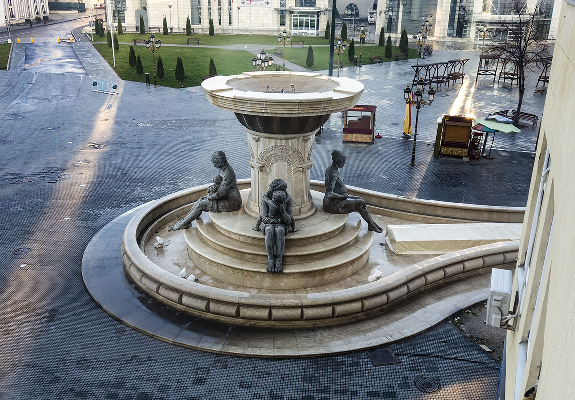
At the northern end of the famous Stone Bridge across the Vardar River in Downtown Skopje, in Karposh’s Rebellion Square (more on the illustrious Karposh later), and just in front of the apartment building where I am staying, is the charming Fountain of the Mothers of Macedonia.

View of the Fountain of the Mothers of Macedonia from the window of the my apartment (click on photos for enlargements)

Fountain of the Mothers of Macedonia 

Mother and Child

Mother and Child

Pregnant Mother-to-be

Fountain Pool
The pool of the Fountain of the Mothers of Macedonia. The fountain is apparently turned off in wintertime. Is it just my imagination, or is the fountain pool shaped like an enormous Vulva?