Attention Cat People! See Catnip over at Don Croner’s Wanders on the Great Allegheny Passage Bike Trail.
Saturday, August 22, 2026


Sunday, August 16, 2026
North Macedonia | Tikves Wine District | Demir Kapiya | Popova Kula Winery | Prokupec
It is my fourth day at the Popova Kula Winery, a Thursday, and I am still the only guest here. I checked on the internet and discovered, however, that this coming Saturday night the place is full-up with no rooms available. Luckily I am checking out Saturday morning. Incorrigible misanthrope that I am, I have been enjoying the solitude. Meanwhile I am continuing my investigations of the local vintages. The winery produces eleven different kinds of wine:
—Stanushina
—Vranec
—Prokupec
—Cabernet Sauvignon
—Merlot
—Sauvignon Blanc
—Temjanika,
—Chardonnay
—Zilavka
— Muscat Ottonel
—Muscat Hamburg
Stanushina, Prokupec, Vranec, Temjanika, and Zilavka are made from grapes indigenous to the Balkan Peninsula; these are the only varieties I am interested in. God forbid that I should come to Macedonia just to drink Cabernet Sauvignon or—horrors!— Merlot!
According to archeological findings, grapes has been grown and wine produced in the area of Demir Kapiya for at least the last 3600 years. The modern history of viniculture in the Demir Kapiya area began in 1927 when King Alexander Karadjordjevic of Yugoslavia (1888–1934) built a winery here to produce wine for the exclusive use of his royal family. Experts assured the king that of all possible locations in his kingdom, which covered a good part of the Balkan Peninsula, including modern-day Serbia, Croatia, Bosnia and Slovenia, this area was the most fertile and best suited for growing grapes and producing wine. He named the property the Winery of The Queen Maria in honor of his wife, Maria Karadjordjevic. The king hired the best vintners available and the winery was soon producing wine of extraordinary quality. Unfortunately King Alexander Karadjordjevic was unable to enjoy the fruits of his vineyards for long. On October 9, 1934, during a state visit to Marseille, France, he was assassinated by Bulgarian revolutionary Vlado Chernozemski.
 |
| King Alexander Karadjordjevic of Yugoslavia (click on photos for enlargements) |
The subsequent history of the winery is a bit hazy, but apparently it continued producing wine in the decades thereafter, except during the world wars and various local upheavals. After the Second World the Royal Winery, along with other wineries in what was then Yugoslavia, were nationalized. Over 30,000 families who owned small private vineyards continued, however, to supply grapes to these wine making facilities. It was these people who are credited with maintaining the high quality of local viniculture during the following decades. After the breakup of socialist Yugoslavia in the 1990s and the emergence of the former Yugoslavian republic of Macedonia as an independent country most if not all wineries were privatized. The royal winery in Demir Kapiya was privatized in 1994 and is now known as the Royal Winery Queen Maria. The current winery has an on-site restaurant and rents out rooms, apartments, and for high-rollers the former villa of Queen Maria Karadjordjevic.
 |
| King Alexander and Queen Maria |
 |
| Popova Kula Winery |
 |
| The “Priest’s Tower” of Popova Kula |
Curious about this Roman road, I went down to the lobby and questioned the receptionist, a charming woman in her thirties. She in turn questioned one the local workmen who happened to be handy, and this guy said the Roman road in question was the famous Via Egnatia dating to the time of the Roman Empire, which ran from Durrës in what is now Albania east 696 miles to Constantinople, right across the heart of the Balkan Peninsula. This was certainly intriguing. I had already visited numerous cities and towns on the old Via Egnatia, including Thessaloniki, Kavala, and Kastoria in Greece and Orhid in Macedonia but I was under the impression that the old Roman road passed through the Balkans a good bit south of Demir Kapiya. The receptionist called the local wine museum and the woman at the museum suggested I stop by for more information. So I hiked a mile into town and found the museum, a modest two-room establishment in downtown Demir Kapiya. The woman in charge informed me that the Roman road through Demir Kapiya was not the Via Egnatia itself but a side branch of the main highway. Nevertheless, I was thrilled to discover that Demir Kapiya was in fact linked to the hallowed Via Egnatia. I harbor the sneaking suspicion I have traveled this road in a previous lifetime.
 |
| The Via Egnatia in red. The northern extension in green may be the one that passed through Demir Kapiya. |
 |
| Via Egnatia near Kavala. Photo by Philipp Pilhofer |
After trekking a mile back from the museum to the winery I retire to my balcony to sample the wine of the day; in this case Prokupec, a wine apparently indigenous to what is now Serbia but also grown in Macedonia.
 |
| Prokupec |
From my balcony can be seen the Iron Gate, a gap in the mountains through which the Vardar River flows. The Iron Gate marks the southern boundary of the Tikves Wine Region. It also gives its name to the town just to the north—Demir Kapiya, which in Turkish means “Iron Gate”.
 |
| View from my balcony. The Iron Gate is the gap in the mountains in the
middle of the photo. The town of Demir Kapiya (Iron Gate) is in the
foreground. |
 |
| A view of the Iron Gate from Popova Kula vineyards |
 |
| Another view from my balcony |
Halfway through my first glass of Prokupec my thoughts drifted, perhaps inevitably, to the Persian Poet Rudaki (858 a.d – 941 a.d.), the favorite poet of the Samanids of Bukhara, in what is now Uzbekistan. The Elton John of his Age, at one point Rudaki owned two hundred slaves who attended to his every need, and a hundred camels were necessary to carry his baggage when he traveled. His verses, it was said, filled a hundred volumes; he reportedly wrote 1,300,000 couplets. Almost all of his work has been lost. Unfortunately, the poet came to a bad end. He may have fell under the sway of the Ismaili Sect, considered heretical in the domains of the Samanids, and he eventually fell out of favor with the court. His lament:
Who had greatness? Who had favour, of all people in the land?
I it was had favour, greatness, from the Saman scions' hand;
Khurasan's own Amir, Nasr, forty thousand dirhams gave,
And a fifth to this was added by Prince of Pure and Brave;
From his nobles, widely scattered, came a sixty thousand more;
Those the times when mine was fortune, fortune good in plenteous store.
Now the times have changed--and I, too, changed and altered must succumb,
Bring the beggar's staff here to me; time for staff and script has come!
He reportedly died in abject poverty. Perhaps in his final days he repeated one of his couplets:
Were there no wine all hearts would be a desert waste, forlorn and black,
But were our last life-breath extinct, the sight of wine would bring it back.
 |
| Rudaki |

A white wine, Zilavka, that I tried earlier. It is also indigenous to the Balkan Peninsula. I am not a big fan of white wine, but this one was not bad at all. It was flirtatious but not presumptuous; sassy, without being impertinent.
 |
| Another view of the winery |
Thursday, August 6, 2026
North Macedonia | Skopje | Fountain of the Mothers of Macedonia
At the northern end of the famous Stone Bridge across the Vardar River in Downtown Skopje, in Karposh’s Rebellion Square (more on the illustrious Karposh later), and just in front of the apartment building where I am staying, is the charming Fountain of the Mothers of Macedonia.
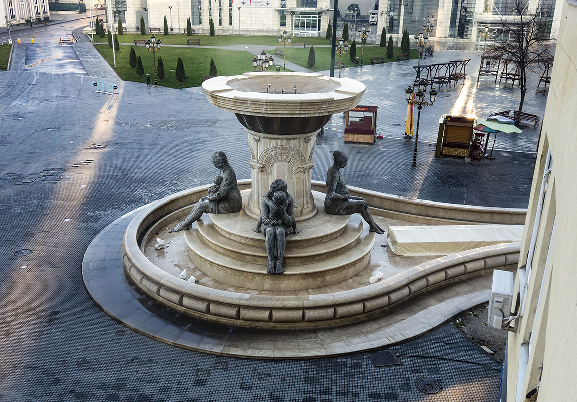 |
| View of the Fountain of the Mothers of Macedonia from the window of the my apartment (click on photos for enlargements) |
 |
| Fountain of the Mothers of Macedonia |
 |
| Mother and Child |
 |
| Mother and Child |
 |
| Pregnant Mother-to-be |
 |
| Fountain Pool |
The pool of the Fountain of the Mothers of Macedonia. The fountain is apparently turned off in wintertime. Is it just my imagination, or is the fountain pool shaped like an enormous Vulva?
Wednesday, August 5, 2026
North Macedonia | Skopje | Stone Bridge
 |
| Macedonia Square with statue of Warrior on a Horse (Alexander the Great, but don’t tell anyone). Click on photos for enlargements. |
The northeast side of 435 foot-long and 250 foot-wide Macedonia Square faces the famous Kameni Most, or Stone Bridge, across the Vardar River. The 241 mile-long river, which drains at least two-thirds of the country and divides the city of Skopje into two parts, finds its source only about eighteen miles to the northwest of Skopje, near the Kosovo border, but loops far to the south before heading north to Skopje, picking up many tributaries along the way, including the sizable Treska River (home of the famous Matka Canyon resort area), which flows into the Vardar 4.5 miles upstream from downtown, and has already grown into a sizable stream by the time it flows through the city. The river continues on to the southeast and crosses the Greek border near the town of Axioupoli, where is suddenly takes on the Greek name of Axios River, before flowing into the Aegean Sea west of the city of Thessaloniki in northern Greece. The meaning of “Vardar” is much debated, but the name it probably based on an ancient Proto-Indo-European word meaning “Black Water”.
 |
| The Stone Bridge |
The Kameni Most, or Stone Bridge, across the Vardar, has become a symbol of Skopje and is found on the city’s coat-of-arms and on the city flag.
 |
| Skopje-coat-of-arms |
 |
| Byzantine Emperor Justinian I (r. 527-565) |
 |
| Justinian |
Justinian is perhaps most famous for building Hagia Sofia in Constantinople (Istanbul), to this day one of the world’s most magnificent edifices (it was first a church, then a mosque, and now a museum), and for marrying the notorious ex-prostitute Theodora.
“Glory to God, Who has deemed me worthy of fulfilling such a work. O Solomon, I have surpassed thee,” Justinian reportedly said when entering the newly completed Hagia Sofia for the first time. History does not record what he said after entering Theodora for the first time.
 |
| Interior of Hagia Sophia |
 |
| Four of the twelve arches of the Stone Bridge |
The bridge built by the Ottomans was heavily damaged during an earthquake in 1555 and eventually repaired. Further repairs and renovations took place in the 18th, 19th and early 20th centuries, with the last update in 1994. In 1944 Nazi troops who had invaded Macedonia rigged the bridge with explosives, intending to destroy it to cover their retreat, but this plot was foiled and the bridge survived.The current bridge, 702 feet long and twenty feet wide, consists of columns of huge stone blocks divided by twelve semicircular arcs.
 |
| View downstream from the Stone Bridge, toward the Bridge of Civilizations in Macedonia, also known as the Eye Bridge. |
 |
| View upstream from the Stone Bridge. Another pedestrian bridge is under construction. |
About two-thirds of the way across the bridge is a column containing a mihrab, or prayer niche, apparently pointing in the direction of Mecca, dating to 2008, although there may have been an earlier version.
 |
| Prayer niche on the bridge |
| A bit further on, on the other side of the bridge is an historical signpost marking the spot where the illustrious Karposh, the Christian leader of an anti-Ottoman uprising in 1689, was executed by the Ottomans. The northern end of the bridge debouches onto Karposh Square, named after the Macedonian freedom fighter. |
 |
| Sign indicating where Karposh was supposedly executed |
 |
| Northern end of the Stone Bridge debouching onto Karposh Square |
 |
| Statue of Karposh |
 |
| Statue of Karposh |
 |
| Statue of Karposh |
North Macedonia | Skopje
When residing in Mongolia I usually do not break out my winter coat until temperatures fall to –10ºF or colder. Until then a down jacket is usually sufficient. A few days ago the temperature dropped to –16ºF. As I was digging out my winter coat a thought hit me. Instead of breaking out the winter coat why not just head for warmer climes? I checked the weather in various cities and discovered that it was a relatively balmy 62ºF in Skopje, Macedonia, a city that I had visited before and found quite appealing. I immediately booked a Flight On Turkish Airlines to Skopje. The plane left Ulaanbaatar at six o’clock the next morning. After an eleven hour flight (including a one hour layover in Bishkek, Kyrgyzstan) I arrived in Istanbul, where I spent the night in a hotel near the airport, and early the next morning caught the one hour and fifteen minute flight to Skopje. From the airport I took a taxi to my hotel in the Stara Charshiya, the old bazaar quarter of Skopje.
 |
| Macedonia, in the middle of the Balkan Peninsula (click on photos for enlargements) |
Macedonia, a former province of Yugoslavia and now an independent country, is officially named the Former Yugoslav Republic of Macedonia, an unwieldy name that pleases nobody. Attempts to change the name are now underway (more on this extremely contentious issue later). Located in the heart of the Balkans, Macedonia—most people use the shorthand name—is surrounded by the countries of Kosovo, Serbia, Bulgaria, Albania and Greece and covers 9,928 square miles, making it slightly bigger than Vermont and slightly smaller than Massachusetts. Put another way, sixty-six Macedonias would fit inside the borders of the state of Alaska, and sixty-one within the borders of Mongolia. The population is roughly 2,100,000, with 507,000 living in Skopje. About 65% of Macedonians are Christians; 35% are Muslims. As of 2012, the country had 1,842 churches and 580 mosques. The vast majority of the Christians belong to the Macedonian Orthodox Church, which became autocephalous, or self-ruling, in 1967 and is not officially recognized by any of the other branches of Eastern Orthodoxy.
 |
| Former Yugoslav Republic of Macedonia—for the moment. |
The city of Skopje is divided into two parts by the 241 mile-long Vardar River, which drains at least two-thirds of the country. The Vardar starts only about eighteen miles to the northwest of Skopje, near the Kosovo border, but loops far to the south before heading north to Skopje, picking up many tributaries along the way. It has already grown into a sizable stream by the time it flows through the city. The river continues on to the southeast and crosses the Greek border near the town of Axioupoli before flowing into the Aegean Sea west of the city of Thessaloniki in northern Greece. The name “Vardar” is probably based on an ancient Proto-Indo-European word meaning “Black Water”.
 |
| Center of Skopje. The Stone Bride can be seen in the middle. |
 |
| The boisterous Varder River |
The Stone Bridge connecting Macedonia Square, in the center of Skopje, to the Old Bazaar, where I am staying, is the oldest bridge in the city. The 702 foot-long, 20-foot wide bridge was built by order of Ottoman Sultan Mehmed II the Conqueror between 1451 and 1469 on foundations of an earlier bridge dating to the time of the Roman Empire.
 |
| The Stone Bridge |
 |
| One of several pedestrian bridges across the Vardar |
 |
| Statue in Macedonia Square, in the center of Skopje. It is generally thought to be a statue of Alexander the Great, although that is not its official name. More on this later . . . |
Subscribe to:
Posts (Atom)