Wednesday, August 5, 2015

Mongolia | Khövsgöl Aimag | Source of the Yenisei River

I rose just as the last stars were fading from the sky. Only Jupiter still glowed brightly over the southwest horizon. I kindled the fire, brewed up a pot of Puerh Tea (eight year-old "Autumn Di Jie" brand puerh tea from Yunnan Province, China, with earthy hints of tobacco and chocolate), and sat on my carpet drinking tea as the sky shaded from pearly gray to azure, with not a cloud from horizon to horizon. Two hours later everyone was finally up and we discussed our plans for the day. Batmönkh said the source of the Mungaragiin Gol was just over a low pass to the southwest, where Jupiter had been shining in the morning. The route to our next destination, the source of the Khoogiin, however, was over the pass at the head of the valley we were in, to the northwest. He now suggested that Bayarkhüü and I ride to the source of the Mungaragiin ourselves while he and the others stayed in camp. When we returned we would break camp and cross the pass to the northwest. This way we would not have to backtrack with the pack horses. I agree to this. Yooton announces that she does not want to miss out on anything and will come along with Bayarkhüü and me. That’s fine with me.
Valley of the Mungaragiin, with Belchir Uul in the distance (click on photos for enlargements)
The low pass is only about a mile and a half away. To the left, down the valley of the Mungaragiin Gol, can be seen Mungaragiin Nuur (lake). At the valley, at its head, we get our first glimpse of 10,994-foot Belchir Uul, the highest peak of the mountains to the west of the Darkhad Depression. The source of the Mungaragiin Gol is right at the base of this mountain. Heading upstream, we ride by a small lake dotted with sea gulls. Had they come from the ocean? The Arctic Ocean is over 2000 miles away to the north. Further on is another small lake, this one still almost completely ice covered.
First Lake
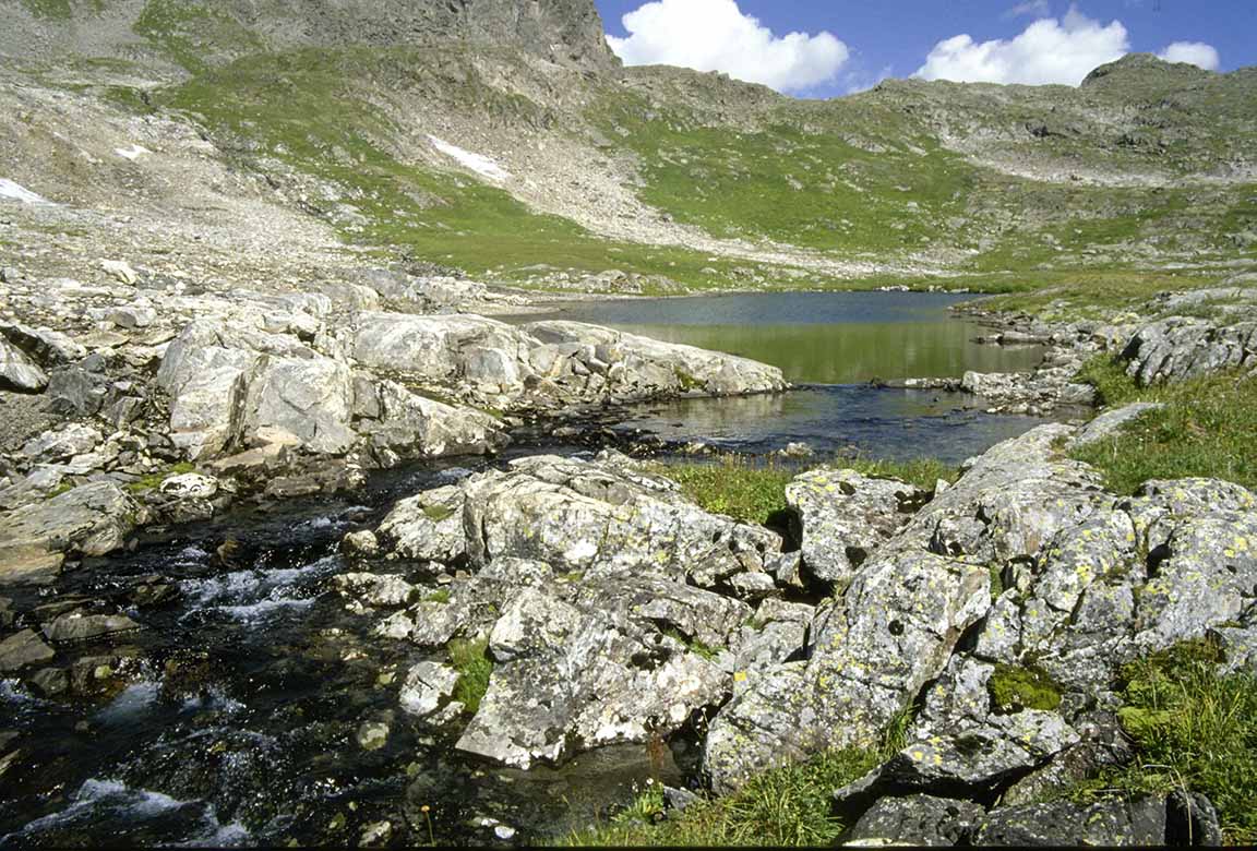
We ride on another half mile to yet another small lake. According to my map, there are several small ponds still further on in the cirque directly below Belchir Uul, but there is no water flowing down the rocky ravine above the third lake we are on. The ponds apparently drain underground into this lake. Thus the outlet of the lake is, at least at this time of the year, the source of Mungaragiin Gol.
Horses at Second Lake 
Source of the Mungaragiin Gol, and one of three sources of the Yenisei
10,994-foot Belchir Uul
The Mungaragiin Gol, I have determined, is one of sources of the Yenisei River System. The Mungaragiin flows west of here and combines with the Guna Gol to form the Bakhmakh Gol, which we had crossed on the way to Batmönkh’s Ger. According to most sources, including Batmönkh, the Bakhmakh combines with the Altgana Gol, flowing in from the mountains to the east of the Depression, to form the Shishigt Gol, which then flows into Tsagaan Nuur. Some say the river known as the Shishigt Gol begins not at confluence of the Bakhmakh and Altgana but at the outlet of the Tsagaan Nuur. In either case, the Shishigt Gol flows out of Tsagaan Nuur and continues west to the Russian border, where it combines with the Busiin Gol and the Bilin Gol to form the Kyzyl Khem. The Kyzyl Khem then continues west to the city of Kyzyl, capital of the autonomous repubic of Tuva, where it combines with the Biy Khem to form the Yenisei proper. The National Geographic Atlas of the World lists both the Biy Khem and the Kyzyl Khem-Shishigt as the two sources of the main branch of the Yenisei (zoom in on the Lake Khövsgöl area of the map).

In 1993 I had hiked some sixty miles to the source of the Biy Khem in the extremely remote East Sayan Mountains in the Autonomous Republic of Tuva. A geographer at the Russian Academy Sciences in Irkutsk, in Siberia, where I was living at the time, had opined to me that this was the real source of the main branch of river known as the Yenisei, since the Biy Khem is bigger than the Kyzyl Khem in terms of volume of water where the two come together. But he allowed that the actual drainage area of the Kyzyl Khem system was larger than that of the Biy Khem so it too had a claim to be the source of the Yenisei. It should be pointed out that there is no scientific definition of the source of a river system, and almost any finding is open to interpretation; hence the long running dispute over the source of the Nile, for example, which ended up with One Of The Disputants getting so frustrated he allegedly committed suicide.
Source of the Yenisei-Biy Khem in the East Sayan Mountains, in the Autonomous Republic of Tuva
In any case, it would appear that the outlet of the lake where we are now standing is at least one of the sources of the Yenisei. The location is N50º51.382' / E098.41.223' and the altitude is 7,802 feet. One atlas (no two agree) states the Yenisei branch of the Yenisei River System is 2537 miles long, although it neglects to mention which source it is using as the beginning of the river.

But the hydrology of the Yenisei River System is extremely complicated. Where the westward flowing Angara River, the big, fast-flowing river that runs out of Lake Baikal in Siberia, and the northward flowing Yenisei branch of the river system combine, the Angara is almost twice as big in terms of water volume. Thus by some definitions the ultimate source of the Yenisei River System would be at the beginning of the Angara branch of the system. The largest river flowing into Baikal is the Selenga (Selenge, in Mongolia). The Selenge, in turn, starts at the confluence of the Delger Mörön and Ider rivers in Mongolia. Since the Ider is bigger in terms of water volume its source would be the beginning the Yenisei-Angara-Selenge branch of the Yenisei River System. The Times [of London] World Atlas considers the Yenisei-Angara-Selenge the main branch of the river system and gives its length as 3448 miles, considerably longer than the Yenisei-Biy Khem branch. And it is not clear if the 281 mile-long Ider is included in this measurement. If not then this branch would measure 3729 miles long. This would be in line with the figure of 3742 miles given to me by the geographer in Irkutsk for the Yenisei-Angara-Selenge-Ider. In either case, it would rank as either the fifth or sixth longest river in the world, depending on which atlas we consult. In terms of water volume it is the Largest North-Flowing River in the world. In 1997 I visited Zavkhan Aimag and rode three days by horse to the source of the Ider, which I located near 11,873-foot Öndör Ölziit Uul, at an elevation of 9,880 feet, as described in my book Wanders in Northern Mongolia.
Source of the Yenisei-Angara-Selenge-Ider Gol in Khangai Mountains, Zavkhan Aimag
Another view of the source of the Yenisei-Angara-Selenge-Ider Gol
As we sit by the outlet of the lake, the source of the Mungaragiin Gol, I explain all this to Yooton, who sweet girl that she is listens patiently and nods knowingly every so often to indicate that she is paying attention. I suspect she does not have the slightest interest in what I am talking about. Not everyone shares my fascination with the sources of rivers. Finally it is time to leave. Two hours later we are back in camp where Nergui has a kettle of Yunnan Gold and dinner ready for us. Now I have now been to all three sources of the Yenisei River.
Three sources of the Yenisei River (base map courtesy of The Encyclopedia of Earth)

Saturday, August 1, 2015

Mongolia | Khövsgöl Aimag | Darkhad Depression #1


Aftesr visiting the Deer Stones we continued on to the Darkhad Depression. We stopped for lunch at a guanz (restaurant in a ger) where the road crosses the Beltes River. There were two other customers in the guanz, each nursing a bowl of milk tea: a woman in her fifties and a man perhaps in his mid-thirties. After some chit-chat the woman got up and left. Our driver whispered, “She is a very famous shaman from the Darkhad Depression. She now lives in Mörön.” I knew that the Darkhad Depression was famous for its shamans. On a previous trip the Darkhad Depression back on 1999 I had noticed that very few Darkhads, the ethic group that inhabits the Depression, had any kind of Buddhist regalia in their gers. Most still believe to one degree or another in traditional Inner Asian-Siberian shamanism. The woman soon reappeared in the guanz. I told her we were going to the Belchir Uul area on the western edge of the Darkhad Depression and asked if she had ever been there. “Many times,” she said. Is there much snow there at this time of the year? I asked. “It can snow there any time, but it should be no big problem this time of year. The problem now is flies.” She held up her thumb of her right hand and circled it with the thumb and forefinger of her left land just below the first joint. “Flies this big, she said, indicating her protruding thumb. “They have a big green head and they bite both people and horses. You swell up wherever they bite you. It is not really a good time to go to that area.”


Actually I had been concerned about flies and mosquitoes. I had once hiked in the Lake Baikal area in Siberia in late June when the flies and mosquitoes were simply hellish. The area where we were going was really the southern edge of the Siberian taiga, or forest, and I was afraid of encountering the same conditions. Professor Terbish, a biologist at Mongolia State University who had put me in contact with the local horsemen we were meeting, had opined however that it was a bit early for an insect infestation. We were more likely, he opined, to encounter snow. Personally I preferred snow, but I had brought along a head net for the insects just in case.


North of the Beltes River we entered higher country, finally climbing to 6,923-foot Eliin Davaa, the pass that marks the entrance to the Darkhad Depression. Here there are thirteen ovoos; one big ovoo and twelve smaller ovoos each representing one of the animals of the Mongolian calendar: mouse, ox, tiger, rabbit, dragon, snake, horse, sheep, monkey, rooster, dog, and pig. According to tradition, people entering the Darkhad Depression circumambulate the big ovoo and then pray to the ovoo representing the year they were born. Yooton was born in the Year of Dog, it turns out. I was born the Year of the Ox. Near the ovoos are several stone monuments, once dedicated to the shamans of the area.


Main ovoo at Eliin Davaa


Main ovoo and six of the twelve smaller ovoos


Monument to local shamans


We soon arrive in the tidy little village of Ulaan Uul. There had been some question about how we were going to meet our horsemen, as we had been told they had moved their ger several times already that spring and no one in Ulaanbaatar or our driver knew exactly where they were located at present. We had planned to ask local herdsmen in Ulaan Uul about their current location. Then a motorcycle pulled up alongside us. Behind the young driver was an older man who waved at us to stop. This turned out to Batmönkh, the man from who we were going to rent horses and who was going to act as our guide to Belchir Uul. Jumping into our van, he explained that the current site of his ger was hard to find and that he had come himself to Ulaan Uul to lead us there. Our horses were waiting for us at his ger, he assured us, and he and his son were ready for an eight-day horse trip into the mountains. The weather all spring had been very dry, but on June 2 some lamas from the monastery in Möron came and performed a rain making ceremony at the Noyon Ovoo in the Khogiin Gol Valley, where we would be going, and immediately afterwards there had been several rain and snow showers. It was still raining a bit every day. And the flies were out. "Flies as big as your thumb,” said Batmönkh, echoing the words of the shaman. “They love to bite foreigners,” he said, guffawing loudly. He seemed to be in the best of moods.


North of Ulaan Uul we cross the Bakhmakh River. This stream is formed by two smaller rivers, the Guna Gol, which starts just below Eliin Davaa and is now almost dry, and the Mungaragiin Gol, which begins at the base of Belchir Uul. The source of the Mungaragiin Gol is our eventual destination.


Bakhmakh River


We drive across flat steppe with a thick larch forest on our left until Batmönkh shouts "Turn left here!” We take a vague jeep trail several kilometers through the thick forest before emerging into a long meadow dotted with three small lakes. These are Urd (southern) Tarkhai Nuur, Dund (middle) Tarkhai Nuur, and Ar (behind) Tarkhai Nuur. The meadow itself is also known as Tarkhai. Batmönkh says “tarkhai” means the sole of a shoe, but he is unable to explain why the name is used here. Near the last lake is a single ger where Batmönkh and his family live.


Batmönkh’s ger


We pop into the ger and while we are refreshing ourselves with milk tea, fried bread and homemade unsalted cheese Batmönkh introduces us to his wife and family. He is sixty-five years old, he says, and his wife is fifty-nine. They have eleven children, six boys and five girls. Present are the youngest daughter, sixteen, a twenty-six year old unmarried daughter, and one of the older sons, Bayarkhüü. Bayarkhüü, we are informed, will be going with us on our horse trip. Also present is a twenty-seven year old woman named Nergui, who is a friend of the family. Batmönkh has recruited her to go along on the horse trip as a cook. I had planned to buy a sheep, but now Batmönkh informs us that he was just recently prepared some boortz, or dried meat, made from beef. Long thin strips of this boortz are hanging from the latticework of his ger. He now suggests that we take this boortz inside of killing a sheep. I agree. Then we ask if ask if Nergui can make us some bortsog, or fried bread, for the trip. She inspects the flour I had bought in Möron and for some reason finds it unsatisfactory. Instead she will use flour from one of several huge burlap bags of flour Batmönkh has in his ger.


We go out and set up our tents. Soon Bayarkhüu emerges from the ger with a rifle slung over his shoulder. The night before, he tells us, wolves had raided their horse herd and killed two young foals. Tonight he will stand watch over the herd. “I hope the wolves come back,” he says, patting his rifle. “I will be ready for them.”


Our horses

Mongolia | Khövsgöl Aimag | Darkhad Depression #1

Aftesr visiting the Deer Stones we continued on to the Darkhad Depression. We stopped for lunch at a guanz (restaurant in a ger) where the road crosses the Beltes River. There were two other customers in the guanz, each nursing a bowl of milk tea: a woman in her fifties and a man perhaps in his mid-thirties. After some chit-chat the woman got up and left. Our driver whispered, “She is a very famous shaman from the Darkhad Depression. She now lives in Mörön.” I knew that the Darkhad Depression was famous for its shamans. On a previous trip the Darkhad Depression back on 1999 I had noticed that very few Darkhads, the ethic group that inhabits the Depression, had any kind of Buddhist regalia in their gers. Most still believe to one degree or another in traditional Inner Asian-Siberian shamanism. The woman soon reappeared in the guanz. I told her we were going to the Belchir Uul area on the western edge of the Darkhad Depression and asked if she had ever been there. “Many times,” she said. Is there much snow there at this time of the year? I asked. “It can snow there any time, but it should be no big problem this time of year. The problem now is flies.” She held up her thumb of her right hand and circled it with the thumb and forefinger of her left land just below the first joint. “Flies this big, she said, indicating her protruding thumb. “They have a big green head and they bite both people and horses. You swell up wherever they bite you. It is not really a good time to go to that area.”

Actually I had been concerned about flies and mosquitoes. I had once hiked in the Lake Baikal area in Siberia in late June when the flies and mosquitoes were simply hellish. The area where we were going was really the southern edge of the Siberian taiga, or forest, and I was afraid of encountering the same conditions. Professor Terbish, a biologist at Mongolia State University who had put me in contact with the local horsemen we were meeting, had opined however that it was a bit early for an insect infestation. We were more likely, he opined, to encounter snow. Personally I preferred snow, but I had brought along a head net for the insects just in case.

North of the Beltes River we entered higher country, finally climbing to 6,923-foot Eliin Davaa, the pass that marks the entrance to the Darkhad Depression. Here there are thirteen ovoos; one big ovoo and twelve smaller ovoos each representing one of the animals of the Mongolian calendar: mouse, ox, tiger, rabbit, dragon, snake, horse, sheep, monkey, rooster, dog, and pig. According to tradition, people entering the Darkhad Depression circumambulate the big ovoo and then pray to the ovoo representing the year they were born. Yooton was born in the Year of Dog, it turns out. I was born the Year of the Ox. Near the ovoos are several stone monuments, once dedicated to the shamans of the area.
Main ovoo at Eliin Davaa
Main ovoo and six of the twelve smaller ovoos
Monument to local shamans
We soon arrive in the tidy little village of Ulaan Uul. There had been some question about how we were going to meet our horsemen, as we had been told they had moved their ger several times already that spring and no one in Ulaanbaatar or our driver knew exactly where they were located at present. We had planned to ask local herdsmen in Ulaan Uul about their current location. Then a motorcycle pulled up alongside us. Behind the young driver was an older man who waved at us to stop. This turned out to Batmönkh, the man from who we were going to rent horses and who was going to act as our guide to Belchir Uul. Jumping into our van, he explained that the current site of his ger was hard to find and that he had come himself to Ulaan Uul to lead us there. Our horses were waiting for us at his ger, he assured us, and he and his son were ready for an eight-day horse trip into the mountains. The weather all spring had been very dry, but on June 2 some lamas from the monastery in Möron came and performed a rain making ceremony at the Noyon Ovoo in the Khogiin Gol Valley, where we would be going, and immediately afterwards there had been several rain and snow showers. It was still raining a bit every day. And the flies were out. "Flies as big as your thumb,” said Batmönkh, echoing the words of the shaman. “They love to bite foreigners,” he said, guffawing loudly. He seemed to be in the best of moods.

North of Ulaan Uul we cross the Bakhmakh River. This stream is formed by two smaller rivers, the Guna Gol, which starts just below Eliin Davaa and is now almost dry, and the Mungaragiin Gol, which begins at the base of Belchir Uul. The source of the Mungaragiin Gol is our eventual destination.
Bakhmakh River
We drive across flat steppe with a thick larch forest on our left until Batmönkh shouts "Turn left here!” We take a vague jeep trail several kilometers through the thick forest before emerging into a long meadow dotted with three small lakes. These are Urd (southern) Tarkhai Nuur, Dund (middle) Tarkhai Nuur, and Ar (behind) Tarkhai Nuur. The meadow itself is also known as Tarkhai. Batmönkh says “tarkhai” means the sole of a shoe, but he is unable to explain why the name is used here. Near the last lake is a single ger where Batmönkh and his family live.
Batmönkh’s ger
We pop into the ger and while we are refreshing ourselves with milk tea, fried bread and homemade unsalted cheese Batmönkh introduces us to his wife and family. He is sixty-five years old, he says, and his wife is fifty-nine. They have eleven children, six boys and five girls. Present are the youngest daughter, sixteen, a twenty-six year old unmarried daughter, and one of the older sons, Bayarkhüü. Bayarkhüü, we are informed, will be going with us on our horse trip. Also present is a twenty-seven year old woman named Nergui, who is a friend of the family. Batmönkh has recruited her to go along on the horse trip as a cook. I had planned to buy a sheep, but now Batmönkh informs us that he was just recently prepared some boortz, or dried meat, made from beef. Long thin strips of this boortz are hanging from the latticework of his ger. He now suggests that we take this boortz inside of killing a sheep. I agree. Then we ask if ask if Nergui can make us some bortsog, or fried bread, for the trip. She inspects the flour I had bought in Möron and for some reason finds it unsatisfactory. Instead she will use flour from one of several huge burlap bags of flour Batmönkh has in his ger.

We go out and set up our tents. Soon Bayarkhüu emerges from the ger with a rifle slung over his shoulder. The night before, he tells us, wolves had raided their horse herd and killed two young foals. Tonight he will stand watch over the herd. “I hope the wolves come back,” he says, patting his rifle. “I will be ready for them.”
Our horses

Friday, July 31, 2015

Mongolia | Khövsgöl Aimag | Deer Stones | Graves


Wandered out to Mörön, capital of Khövsgöl Aimag, 575 miles west of Ulaanbaatar ASCF. The plane was supposed to leave at 10:30 am, but due to some unexplained technical problems the flight did not get off until 6:30 pm. The original plan had been to arrive in Mörön at noon, stock up on groceries, and then head north by chartered Russian van into the Darkhat Depression, where we had a horse trip planned. With the late departure we did not arrive until 8:00 pm, after all the stores were closed and it was too late to head out for the day. With the election only two weeks away and all the politicians in town hotel rooms on Mörön were scarcer than in Bethlehem on the first Christmas Eve. The driver of our van allowed us to spend the night in a spare room in his house. The room had no furniture, but nice carpets, so we threw out out sleeping bags and settled in for the night.


The next morning we visited various markets and bought potatoes, carrots, cabbage, onions, rice, flour, salt, sugar, soy sauce, yeast, and for Yooton, who was along as guide and historical consultant, blueberry jam and two kilo of candies (she has a sweet tooth). I had brought tea along from Ulaanbaatar—five-year old Puerh for breakfast, Imperial Gold Needle Yunnan Black Tea for lunch, Taiwan Oolong for dinner, and Tie Kwan Yin (Iron Goddess of Mercy) Oolong for evenings around the campfire—and we intended to buy a sheep to complete our larder when we arrived in the Darkhat Depression. By 11:00 a.m. we were barreling north out of town.


Although we were a bit behind schedule to met our horsemen we made a short detour to visit the Erkhel Ulaan Tolgoi Deer Stone and Grave Complex, twenty-six miles ATCF north of Mörön. One of the more famous Deer Stone sites in Mongolia, it boasts of what is reported to be the tallest deer stone in Mongolia, if not the world. This and several of the other deer stones are quite well preserved, with the carving on them still very distinct. Our driver tells us that a team of American researchers from the Smithsonian Institute has visited this site several times and that they are expected to arrive again in three or four days. In fact, he himself is going to bring them here.


Deer Stones date from the Bronze Age, c. 2500-3000 years ago. They are so called because most of them have depictions of deer, often appearing to be flying through the air. There is much speculation but not much agreement on what the deer and other common motifs on the stones are supposed to mean. They may be what twentieth century magus G. I. Gurdjieff calls “legominisms,” i.e. means by which "ancient wisdom is transmitted beneath a form ostensibly intended for a quite different purpose.” According to Gurdieff the information contained in Legominisms could be interpreted only by initiates of certain ancient wisdom schools. “This information,” says Gurdjieff, “is necessary for subsequent generations to enable them to meet the difficulties that arise in the rise and fall of cultures, difficulties that people believe will never occur again because ‘the world is now different.’” Thus what may appear simply as primitive art to most observers may be encoded messages intended for initiates perhaps thousands of years after their creation.


Certainly down through the ages people have considered this site of some importance. Near the deer stones are several Türk grave mounds dating from probably the seventh century. The largest Türk grave mound is surrounded by a square made of small rocks and measuring about 100 feet on each side. At each corner is a small mound of rocks. The exact significance of these structures is also unknown. Near the Türk tomb are also several Chingis-era tombs dating to the thirteen century. Perhaps the Türks and Chingis-era Mongols understood the true significance of the deer stones and choose this site for the tombs. To my knowledge the code of the deer stones has not yet been cracked by modern observers.


The Deer Stone Complex


5 foot-4 inch Yooton with 12 foot-6 inch deer stone, said to be the tallest in Mongolia


Detail at top of tallest Deer Stones


Well preserved Deer Stone with the equally well preserved Yooton


Detail at the top of Deer Stone. Some commentators believe the circle represents the sun.


Detail at bottom of Deer Stone


Deer Stone with two flying deer at the bottom


Chingis-era grave mound surrounded by a circle of small rocks


Türk grave mound from the seventh or eighth century. This tomb appears to have been looted.


One of the smaller mounds at the four corner of the stone square around the Türk tomb


Mongolia | Khövsgöl Aimag | Deer Stones | Graves

Wandered out to Mörön, capital of Khövsgöl Aimag, 575 miles west of Ulaanbaatar ASCF. The plane was supposed to leave at 10:30 am, but due to some unexplained technical problems the flight did not get off until 6:30 pm. The original plan had been to arrive in Mörön at noon, stock up on groceries, and then head north by chartered Russian van into the Darkhat Depression, where we had a horse trip planned. With the late departure we did not arrive until 8:00 pm, after all the stores were closed and it was too late to head out for the day. With the election only two weeks away and all the politicians in town hotel rooms on Mörön were scarcer than in Bethlehem on the first Christmas Eve. The driver of our van allowed us to spend the night in a spare room in his house. The room had no furniture, but nice carpets, so we threw out out sleeping bags and settled in for the night.

The next morning we visited various markets and bought potatoes, carrots, cabbage, onions, rice, flour, salt, sugar, soy sauce, yeast, and for Yooton, who was along as guide and historical consultant, blueberry jam and two kilo of candies (she has a sweet tooth). I had brought tea along from Ulaanbaatar—five-year old Puerh for breakfast, Imperial Gold Needle Yunnan Black Tea for lunch, Taiwan Oolong for dinner, and Tie Kwan Yin (Iron Goddess of Mercy) Oolong for evenings around the campfire—and we intended to buy a sheep to complete our larder when we arrived in the Darkhat Depression. By 11:00 a.m. we were barreling north out of town.

Although we were a bit behind schedule to met our horsemen we made a short detour to visit the Erkhel Ulaan Tolgoi Deer Stone and Grave Complex, twenty-six miles ATCF north of Mörön. One of the more famous Deer Stone sites in Mongolia, it boasts of what is reported to be the tallest deer stone in Mongolia, if not the world. This and several of the other deer stones are quite well preserved, with the carving on them still very distinct. Our driver tells us that a team of American researchers from the Smithsonian Institute has visited this site several times and that they are expected to arrive again in three or four days. In fact, he himself is going to bring them here.

Deer Stones date from the Bronze Age, c. 2500-3000 years ago. They are so called because most of them have depictions of deer, often appearing to be flying through the air. There is much speculation but not much agreement on what the deer and other common motifs on the stones are supposed to mean. They may be what twentieth century magus G. I. Gurdjieff calls “legominisms,” i.e. means by which "ancient wisdom is transmitted beneath a form ostensibly intended for a quite different purpose.” According to Gurdieff the information contained in Legominisms could be interpreted only by initiates of certain ancient wisdom schools. “This information,” says Gurdjieff, “is necessary for subsequent generations to enable them to meet the difficulties that arise in the rise and fall of cultures, difficulties that people believe will never occur again because ‘the world is now different.’” Thus what may appear simply as primitive art to most observers may be encoded messages intended for initiates perhaps thousands of years after their creation.

Certainly down through the ages people have considered this site of some importance. Near the deer stones are several Türk grave mounds dating from probably the seventh century. The largest Türk grave mound is surrounded by a square made of small rocks and measuring about 100 feet on each side. At each corner is a small mound of rocks. The exact significance of these structures is also unknown. Near the Türk tomb are also several Chingis-era tombs dating to the thirteen century. Perhaps the Türks and Chingis-era Mongols understood the true significance of the deer stones and choose this site for the tombs. To my knowledge the code of the deer stones has not yet been cracked by modern observers.
The Deer Stone Complex
5 foot-4 inch Yooton with 12 foot-6 inch deer stone, said to be the tallest in Mongolia
Detail at top of tallest Deer Stones
Well preserved Deer Stone with the equally well preserved Yooton
Detail at the top of Deer Stone. Some commentators believe the circle represents the sun.
Detail at bottom of Deer Stone
Deer Stone with two flying deer at the bottom
Chingis-era grave mound surrounded by a circle of small rocks
Türk grave mound from the seventh or eighth century. This tomb appears to have been looted.
One of the smaller mounds at the four corner of the stone square around the Türk tomb

Saturday, July 25, 2015

Uzbekistan | Bukhara | Kalon Mosque


Kalon Mosque, right (click on photos for enlargements), with the facade of Mir-i-Arab Madrassa on the left


 Entrance to Kalon Mosque


  Entrance to Kalon Mosque


 Courtyard of Kalon Mosque


  Courtyard of Kalon Mosque


Interior gallery of Kalon Mosque

Uzbekistan | Bukhara | Kalon Mosque

Kalon Mosque, right (click on photos for enlargements), with the facade of Mir-i-Arab Madrassa on the left
 Entrance to Kalon Mosque
  Entrance to Kalon Mosque
 Courtyard of Kalon Mosque
  Courtyard of Kalon Mosque
Interior gallery of Kalon Mosque